
Georgia Developing Maps for Better Broadband Coverage Data

Federal Communications Commission (FCC) mapping has long been criticized for inaccuracies. Now, state and local initiatives are taking up the challenge of poor broadband mapping and developing ways to create their own maps that better reflect the reality of broadband coverage in their communities. The Georgia Broadband Deployment Initiative (GBDI) recently showcased several county-level maps they’ve developed that provide the detail that FCC maps lack.
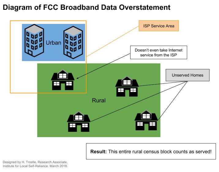
Therein the Problem Lies
As experts have noted, FCC data on which maps are based are inadequate because their foundation is based on census blocks. If one premise in a census block can be served by an Internet access provider, that provider will report on the Form 477 that the entire census block is served. In rural areas where census blocks can be very large tracts of land, this can leave many premises indicated as served but actually unserved.
We developed this graphic to illustrate the issue:
When local communities apply for funding that’s based on the need to connect unserved and underserved premises, they can be disqualified due to incorrect mapping data. For local leaders who need to get their communities connected and expect to apply for grants and loans, FCC mapping can derail their funding and delay or end a proposed project.
This past August, the FCC announced that they will finally take steps to improve mapping and began seeking comments on the new Digital Opportunity Data Collection. Read the announcement [PDF].
Fixing the Maps
In Georgia, the GBDI sought to obtain information on a more granular level to obtain an accurate representation of where residents and businesses need to be connected and where they lack the kind of connectivity they need.


